
The Route
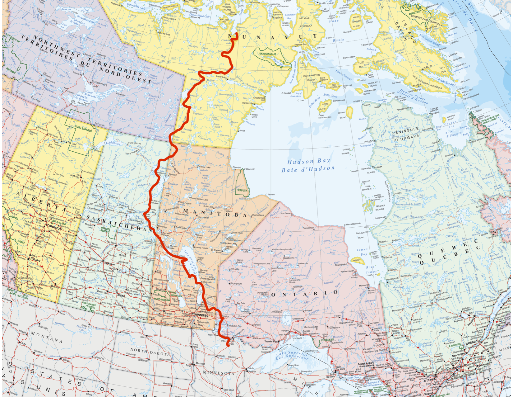
About the route
4,400 km
4 Months
One State, Three Provinces, Two Territories
Two Countries
16 Rivers
Two Canadian Heritage Rivers

Section One
Our trip begins in our home state of Minnesota and not far from Zach’s family hunting cabin. We start with good river travel on the seldom paddled Big Fork River before emptying into the historic Rainy River. The Rainy River country is known for its history in the logging industry, gold rush, as well as part of the historic Voyageurs Highway from Lake Superior to Lake Winnipeg and Hudson Bay.
The Rainy River will feed into our first big lake, Lake of the Woods on the border on Minnesota and Ontario where we will navigate its big waters and many islands before jumping onto the Winnipeg River around Kenora, Ontario. From here, we will descend the Winnipeg River and its few hydro dams on our way to the big lake.
Lake Winnipeg is our biggest lake of the trip. From here, we will start by paddling its eastern shore before jumping over to its western side about 1/3 the way up the lake. A relatively shallow lake and known for holding paddlers windbound for days at a time.
As we exit the big lake, we begin our upstream portion of the trip paddling up the Saskatchewan River before entering the faster Sturgeon-Weir River to its watershed divide with the Churchill River. This route to the NW of Lake Winnipeg is a historic route followed by fur traders and voyageurs out of Lake Winnipeg and into the North and West.

Section Two
At the end of our time on the Sturgeon-Weir River near Pelican Narrows, we will take the historic Frog Portage into the famed Churchill River, which flows east to the town of Churchill and to Hudson Bay. We will be on the Churchill River for a relatively short period of time before cutting north again on the large Reindeer River as it enters the southern part of Reindeer Lake.
Near the town of Southend, we plan to take a series of lesser-used streams and lakes to the west of Reindeer Lake to bypass the large section of the lake. We will then enter the small rivers of the Swan and Blondeau as they connect between Reindeer and Wollaston Lake.
On Wollaston Lake, we are in a unique location as its waters flow to both north to the Arctic Ocean, as well to the east to Hudson Bay. We will enter the Cochrane River from its north end and descend it until we take the historic portages linking the Cochrane to Fort Hall Lake and the Thlewiaza River.
We cut NW off the Thlewiaza River and onto the seldom paddled Little Partridge route into Kasba Lake and the Kazan River. The Kazan is a Canadian Heritage River known for its Inuit history as well as its beauty. We will cut off the Kazan on Angikuni Lake, where we will take unnamed lakes and rivers into Dubawnt Lake for the last section of our trip.

Section Three
We will be entering Dubawnt Lake from its SE side. Depending on the wind, we will either follow the course of the lake or use a series of unnamed lakes and rivers to cut off its east end into Outlet Bay to avoid being windbound on the big part of the lake. We will descend the last section of the Dubawnt and it flows through its final lakes and rapids before spilling into the Thelon River.
Along the Thelon River, we will cross its flat water section of both Aberdeen and Schultz Lake before the river begins to narrow as it pours into Baker Lake. Just before Baker Lake, we will turn north once again with a small series of portages connecting the Thelon with the Meadowbank River. We will travel down the seldom paddled Meadowbank River as it flows into the last bit of the mighty Back River shortly after Wolf Rapids.
From here, the last part of our expedition takes us through large and narrow sections of the Back River, Franklin Lake before emptying into Chantrey Inlet on the Arctic Ocean.

Historic Significance of The Route
There is a lot more to this route than the rivers, lakes, portages, and scenery. Engraved in each section of the route is a ton of historic significance, a large reason we chose to do each of the waterways that make up this route. From its beginnings in Minnesota to Chantrey Inlet on the Arctic Ocean, every place in between is steeped in the long-standing history of many different indigenous groups and cultures.
In addition to the indigenous uses of these landscapes, lakes, and rivers to access ancestral hunting and fishing locations, these lakes and rivers were widely used by trappers and fur trade voyageurs to haul goods from one location to the next.
Over time, many of these routes were told through expedition journals, books, etc. by some of the early travelers. In addition to their writing, maps were drawn of these routes. The map on the right shows the routes traveled by J.W. Tyrell in his expeditions across the Arctic through the Dubawnt, Kazan, and Thelon Rivers in the late 1800’s.
The long-standing stories told by people like George Back, Samuel Hearne, J.W. Tyrell, and so many others have long drawn paddlers into these areas of the Arctic. We are excited to retrace so many of these historic routes and link them into one continuous route.
During the trip, we plan to bring first-hand accounts we can find from some of the early travelers to see what parts of the landscapes are similar and different hundreds of years later.